Assam’s Massive Earthquake: Why Does the North-East Often Experience Quakes?
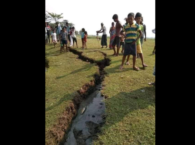
Image Source: Internet. The Cracks in Soil after the massive earthquake.
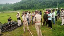
On Wednesday, April 28, Assam woke up to a massive earthquake – its magnitude was determined at 6.4 on the Richter scale and aftershocks were also felt in some places. While two casualties were reported, the quake also caused much damage to buildings.
The epicentre of the quake was close to Hugrajuli village, which is situated in the Himalayan foothills in Sonitpur district. Dr. Sarat Phukan, who heads the Geology Department at Gauhati University, said villagers in Hugrajuli heard thunder-like crackling sounds beneath the hills, a noise which could also be heard in Dhekiajuli town, about eight kilometres from the village. Those working in paddy fields found it difficult to stay on their two feet, trees shook as if there was a massive gust of wind and ponds saw waves. The area witnessed several aftershocks.
Seismic Character of the Region:
North-East India is a highly fragile and earthquake-prone zone. Geomorphologically, the region falls under the highest seismic potential zone V and IV, an area prone to seismic activity and earthquakes.
The earthquakes in Assam in 1897 and 1950 are well known. For those above the age of 80 the ravages of 1950 still remain vivid. The earthquake, which clocked 8.7 on the Richter scale, changed the topography of the land with even the river Brahmaputra unable to escape from changing itself. It is said that its aftershocks could be felt for until a month after it hit.
“The massive earthquake and its aftershocks could bring about changes in the landscapes. However, the casualties were less then because during that period there were no large-scale townships, the population was much scattered, people had traditional houses,” said Dr. Phukan.
“With the population structure we have now in the townships – built mostly on lackadaisical planning – an earthquake of that intensity would cause devastation beyond control,” added Phukan.
The 1897 earthquake was no lesser in its intensity; it was estimated to have measured between 8.15 and 8.35 on the Richter scale. That quake is now confined to the pages of history. Notably, there were no seismographs that could record the magnitude of earthquakes back then. Its details could only be estimated later with the help of thorough studies by Richard Dixon Oldham, the legendary British geologist.
What makes the region so prone to earthquakes is a pivotal question that researchers have long-been engaged in. Dr. Phukan explained: “Assam is surrounded by many tectonic provinces – Eastern Himalayas to the north, Misimi Basin to the east, Indo-Myanmar to the south-east and the Shillong Plateau in the south. Each of these tectonic provinces has numerous faults and the faults are where the earthquakes occur. This reality makes the region very seismologically active and as a result we get frequent earthquakes, some with wide-scale devastations and some with no major impact.”
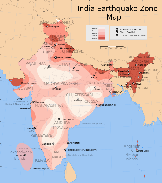
Image Source: Wikipedia Commons. The Earthquake Zone Map of India. The entire NE region is depicted in Red.
“The 1897 earthquake occurred in the Shillong Plateau while the 1950’s earthquake occurred in the Misimi Basin,” Phukan added.
Another aspect due to which some quakes in the region turn devastating is the depth of the epicentre. The greater the depth where a quake is centred the lesser the devastation; a smaller depth results in a more ravaging effect on the ground. The earthquakes that caused huge destruction in Nepal in 2015 were shallow ones, coming about five kilometres beneath the surface.
Wednesday’s earthquake in Assam was also a shallow one, at nearly 10 kilometres below the ground, according to Phukan. “Had this epicentre been located at a depth of five kilometres, then half of Guwahati city would have suffered major destructions,” he claimed, mentioning that the 1897 and 1950 quakes also hit at a shallow depth.
Notably, the Indo-Myanmar tectonic province has the maximum numbers of earthquakes, however, the majority of these have epicentres which are much deeper, about 70 kms beneath the ground on an average. A research paper published in the 'Journal of Asian Earth Sciences' in the year 2017 assessed the earthquake potential of the region and also elaborated on the pattern of seismic activity in the region.
The Kopili Fault:
The NCS (National Centre for Seismology) said that the tremors felt on Wednesday were attributed to the Kopili fault zone.
“The Kopili fault starts from Manipur and extends to Bomdila in Arunachal Pradesh, crossing Assam transversely. This fault nearly covers the Kopili river (from beneath). The fault has a history of earthquakes and is extremely active seismologically,” Dr. Phukan said. The Kopili fault is about 300 kilometres long and 50 kilometres wide.
A fault is a region where earthquakes occur; it is a fracture or zones of fractures between two blocks of rocks. The fracture allows the blocks of rocks to move relative to each other.
The tremors that Assam felt on Wednesday are alarming for disaster management authorities. This is one of the major jolts that the state has experienced. With increasing urbanisation and densely populated areas, the risk of destruction increases manifold. For example, in Guwahati, many people inhabit the hill slopes, which are the most dangerous areas, according to Phukan. “If landslides occur in these areas, then the existing state of disaster management would not be able to handle the situation,” he added.
Another observation made by seismologists is that most of the devastating earthquakes occur in this region during the rainy season which makes the hill slopes already slippery.
There is also a wide gap in earthquake research and infrastructure in the north-east, especially Assam. Sources said that the only major seismograph network currently available to Assam is by the NCS. Earlier, the NEIST (North East Institute of Science and Technology), Jorhat, Assam, had another such network. However, this has apparently become non-functional since 2017, due to funding issues, according to a researcher at NEIST.
Get the latest reports & analysis with people's perspective on Protests, movements & deep analytical videos, discussions of the current affairs in your Telegram app. Subscribe to NewsClick's Telegram channel & get Real-Time updates on stories, as they get published on our website.