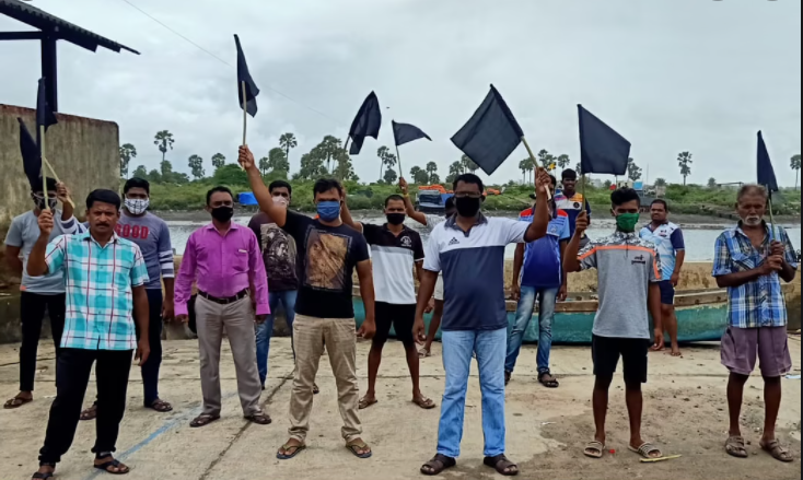
Maharashtra CZMP: Villagers from Palghar and Sindhudurg Protest Against Government Clearances
The state government in Maharashtra government has initiated a significant overhaul in rules that govern the development of its coast. Until now, the protection and development of the coast was decided by the Coastal Regulation Zone Notification (2011), which defined which areas fall under the CRZ and what activities are permitted there. In order to implement the new norms, the government had initiated an extensive satellite mapping process, conducted by the National Centre for Sustainable Coastal Management in Chennai. However, locals from Palghar and Sindhudurg have been vehemently opposing the reports submitted by the institute, as they say the reports are far removed from the on-ground reality.
This week, the government stated that the public consultation process for the maps under draft coastal zone management plan (CZMP) had been completed. The move was met with protests with activists saying there were no public hearings or any consultation with local fishing communities, which will bear the brunt of the hurried move, said to be intended to benefit corporate projects slated to be announced in the region.
No Notice of Public Hearings, Local Topography Ignored
Draft CZMP maps were prepared by the NCSCM, under the Union Ministry of Environment, Forest and Climate, in 2019, for all coastal districts in Maharashtra, based on the 2019 Coastal Regulation Zone (CRZ) norms. The maps were published on January 22 this year.
The maps use colour codes to differentiate CRZ areas (I to IV), intertidal areas, mangrove forests, high tide and hazard line, turtle nesting sites, fishing zones, cyclone shelters and so on. These maps also pick out coastal areas which could be used for infrastructure development. Public consultations, especially with local communities, is compulsory before the maps are finalised. Except for Palghar and Sindhudurg, consultation happened for other districts by March 6, given the lockdown restrictions amid COVID-19.
The state government informed the principal bench of the NGT, that given the pending finalisation of CZMP, no approvals are being granted for any development in coastal areas and that it is ensuring no violations occur in the CRZ areas. Locals suggest that the government is using the pandemic to push for a hurried approval of the maps.
Speaking to NewsClick, Dhwani Shah, an environmental activist from the state, said: “Public hearings were supposed to be held in both Palghar and Sindhudurg. However, notices were given only three days prior to the date. The government mandates 30 days to be given to create awareness of the hearing. The online hearing held on September 30 could not happen as nobody could join. Later, the hearing was called off and a press notice was released in the evening. Prior to this, on we were told on September 29 that they will conduct the hearing at selected taluka level 2 panchayat offices, even though they were given only three hours to reach the venue.”
Highlighting the collapse of public participation, she said that the government is “likely to say that public hearing was done and will hurriedly approve these plans. The fisherfolk do not need these plans, the villages do not need it. It is instead the government of the state which needs their permission for clearances.”
The maps miss out on important ecological features like local markets, homes, dry zones and also common properties of the villages. The problematic satellite mapping is likely to trigger approvals for future projects based on the incomplete information. As the overhauled CRZ rules do not mandate environmental clearances, it may have tremendous repercussions for coastal communities.
Speaking to NewsClick, Nandan Vengrulekar, regional coordinator of the Janjagruti committee said: “Where are the fishing grounds which have been identified? If they are damaged tomorrow who will the fishermen ask? The plan will cover multiple villages, where the government will allow corporate projects.”
He said that between one to four lakh families are likely to get affected. “We have been struggling for the past 15 to 20 years to get someone to come on the ground, conduct surveys and make the maps,” he said, adding that those sitting in Delhi and with mapping never happening on the ground. “We want clarity over who has the government spoken to locally. We have been raising these questions since February. In Maharashtra, the notifications were not circulated in local languages. We needed the report to be widely circulated, booklets distributed door to door. It was the duty of the government to explain these rules to everyone but they did not do so,” he added.
The Modi government has approved an overhaul of the Coastal Zone Regulation (CRZ) rules. The new rules will allow “public utilities” like sewage treatment plants, link roads, coastal roads, and ecotourism projects in CRZ 1 or the most protected and the regulated zones. The government is trying its best to brand the move as one that will lead to significant employment generation and rejuvenate the coastal areas while reducing their vulnerabilities. Fishermen, activists and environment experts on the ground suggest otherwise. The move is set to promote commercialisation in the most protected zones which can have disastrous consequences for the communities living on the coastline and also the environment.
Get the latest reports & analysis with people's perspective on Protests, movements & deep analytical videos, discussions of the current affairs in your Telegram app. Subscribe to NewsClick's Telegram channel & get Real-Time updates on stories, as they get published on our website.