Residents of Raini Village, Once Famous for Chipko Movement, Await Rehabilitation
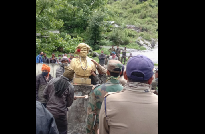
Photo Courtesy. Atul Sati
The village of Raini in Uttarakhand's Chamoli district was once home to India’s most famous forest conservation movement, the ‘Chipko Aandolan’. It is now a site too dangerous for its residents to live on. The village has been in the eye of the storm with scores of landslides and flash floods making an appearance every now and then.
Expressing their grief, the villagers could not believe that Raini, that once had global recognition for its ecological consciousness, now has to fight for its existence. Villagers are yet to overcome the massive flash floods that had ravaged Raini village on February 7 this year following a glacier coming unstuck and an avalanche in the Alaknanda River. The huge mass of snow, water, boulders and silt slithered down Rishiganga River, first damaging the 13 MW private Rishi-Ganga hydel project and then flowing down to Dhauliganga River to swamp the NTPC-owned 520 MW Tapovan-Vishnugad hydropower project.
On June 14, incessant rains in the region brought back memories of the nightmare. The Rishiganga had swollen due to torrential rains for three days straight, causing soil erosion from underneath the village. This led to big cracks in several houses, instilling fear among the villagers. According to reports a large portion of the Joshimath-Malari road beneath Raini village caved in, cutting off around 22 border villages of Chamoli district.
Recently, the statue of Gaura Devi, who had led the Chipko movement in 1973, was moved from Raini to a safer place in Joshimath.
“People of Raini village feel deeply connected to her iconic statue. When it was destabilised due to the road caving in, people wanted to keep it safe within the village, but due to the lack of a proper place, the local administration has now stored it in the municipal corporation office in Joshimath,” Bhawan Rana, the village pradhan, told Newsclick.
“The massive debris from the February 2021 disaster, which had been deposited beneath the village on the banks of the river and which no state agencies could remove, was also washed away in the rains. Dead bodies feared buried under it seem to have been swept away in the torrential current,” Pawan Rana, a resident of the Raini village, told Newsclick.
The management and workers of Tapovan Vishnugad HPP, who were still engaged in clearing the debris and slush deposited in its main tunnel since February, also lost their main approach road as well as an alternative approach. Due to this work in the main tunnel has been halted for over a month now.
With Raini becoming vulnerable to natural disasers, locals have been seeking evacuation and have been pressing for rehabilitation to a safer place. The Uttarakhand government addressed it by appointing a team of geologists to conduct a survey of the village. Their survery declared that the area was quite prone to natural disasters.
The Alaknanda River has been eroding the river bank and moving closer to the village with every incident. According to Nand Kishore Joshi, a Disaster Management Officer, the lower areas of Raini village that house around 55 families are not fit for human settlement. These families are likely to be rehabilitated to Subhai Village.
There is a consensus among meteorologists and geological experts that the Himalayan state is in the firing line of climate change and global warming. According to Mahesh Palawat, Meteorologist, Skymet Weather: “There has been a significant rise in extreme weather events across the state, with a steep rise in frequency as well as intensity of relentless rainfall, cloud burst, flash flooding, landslides and mudslides. Deforestation has also been the major cause of these disasters.”
Chamoli and Bageshwar districts have seen torrential rains since June 1, particularly between June 9 and June 22 this year. Both the districts are reporting large excess rainfall at present. Bageshwar has recorded multiple times its average rainfall with a total of a whopping 901.3 mm of rain between June 1 and July 27 against the normal of 327.9 mm. The situation is similar in Chamoli with 561.8 mm of rain so far in the season against a normal of 268.9 mm of rains.
Sharad Chandra, Director of Flood Forecasting & Monitoring, Central Water Commission said: “Himalayan systems are very young and fragile, making them unstable. If a landslide comes down to the river stream, it increases the chances of floods. Also, commercialisation and urbanisation have led to decrease in soil infiltration capacity, resulting in floods.”
According to Atul Sati, a local environmental activist, the manifold increase in the tourist influx over the years – from around six lakh tourists per year to over 15 lakhs – has led to an increase in vehicular pollution, river pollution, construction activities and commercialisation. The construction of hydropower projects and road widening activities have had a major impact in the region. All these factors have contributed to an increase in temperatures along with a change in rainfall pattern.
Raini village is located at an altitude of 3,700 meters above sea level, on the upper slopes of River Rishiganga. With such a high gradient, the chances of soil erosion and landslides increase manifold. The impact of gravity also increases at this altitude, resulting in more damage and the erosion of river banks. Events witnessed near Raini village over the last few months are witness to such facts.
Professor Y.P. Sundriyal, head of the department of Geology, HNB Garhwal University, said: “There is a huge gap between planning and implementation. Policy makers should be well versed with the geology of the region. Policy and project implementation should consist of local geologists who understand the terrain well and how it responds.”
The Border Roads Organisation has constructed a road just above Raini village, which it plans on further converting into a national highway. The road is reportedly built on the agricultural land of Raini village and is 40 meters length in and ten meters wide. Though the infrastructure will be built given the strategic significance of the region, but geologists have declared the region unfit for human settlement.
Villagers have also been demanding permanent rehabilitation to another place where they would feel safer. State officials have reportedly marked Subhai village for their relocation, which is about five kms south of Raini. However, this will not be an easy task. According to district officials, land is a limited commodity and thus, relocation of villages is not an easy task.
“The relocation of a bunch of people to another place also has an impact on the irrigation, which directly means division of grazing and cultivation land among a larger number of people. Hence, we would try to relocate the affected families within a radius of 300 to 500 meters, so that they would not have to deal with difficulties,” said Joshi.
The writer is a Chandigarh based freelance journalist who tweets @seema_env
Get the latest reports & analysis with people's perspective on Protests, movements & deep analytical videos, discussions of the current affairs in your Telegram app. Subscribe to NewsClick's Telegram channel & get Real-Time updates on stories, as they get published on our website.