Hyderabad Floods: How a ‘Global Vision’ for India’s Cities Has Compromised Liveability
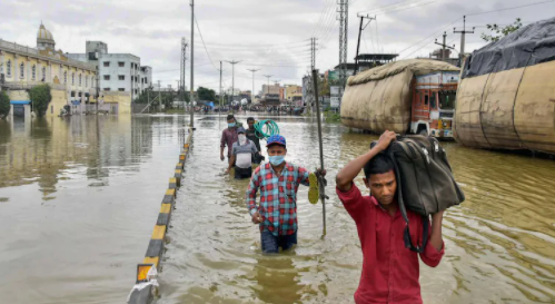
Image Courtesy: PTI
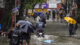
Its been over a month since Hyderabad flooded, and there are still areas in the city which continue to deal with its aftermath with rainwater yet to recede. While Hyderabad continues its infrastructural development under the rubric of missions like the Smart City mission, it remains ill-equipped to deal with its annual rainfall, let alone extreme rainfall events like the recent floods.
On September 30, in the run up to the civil polls in Hyderabad, the State Minister for Urban Development and IT, K.T. Rama Rao, announced that the government had spent over Rs 67,000 crore over the past five years on various development works throughout the city. The declaration came just a few days before the city was brought to its knees by the devastating floods on October 13. Despite the investment, Hyderabad’s unpreparedness surely calls for a hard look into understanding what happened and how the impact can be mitigated in the future.
The city’s history of responding to disasters such as floods, or even events of heat stress remain reactionary measures which do not last long. When such reactionary measures are part of city planning, where does climate resilience come in? More importantly, what does climate resilience mean for Indian cities? The focus of urban planning has to increasingly take into account the transient nature of the city and its population.
Hyderabad is not alone in facing the repercussions of human-induced climate change. Mumbai, Bangalore and Chennai have all experienced damaging levels of flooding. The latter two also contend with a depleting groundwater supply and various cities have been experiencing intolerable heat waves. This, along with Delhi’s out-of-control air pollution, reinforces that this is not a problem unique to Hyderabad, but rampant across India.
The last time the city of Hyderabad faced such intense rainfall was more than a hundred years ago, in 1908. In response, the then ruler of Hyderabad, the Nizam, built the Osman Sagar and Himayat Sagar dams, which simultaneously protected the city from flood waters and provided drinking water. The way city planning took shape after the floods set the tone for infrastructural development for Hyderabad, its commons and its resources. Commons such as agricultural lands, rivers, lakes, streams, pasture lands thrived under the Nizam administration. A look back at Hyderabad’s urban development, urbanisation and its flood management policies since those floods hints at why the floods in 2020 were as devastating and what future city planning desperately needs.
The idea of infrastructure development for a metropolitan has, so far, meant the metro, bridges, roads and buildings, which today represents civic infrastructure. However, what is often overlooked are energy, water, spatial, and people’s infrastructures.
What Happened After 1908?
As part of the measures to protect the city from future floods, river banks between the Chaddarghat and the Purana Pul bridge were raised by 30 ft andlined with parks and government buildings – the high court, city college, Osmania Hospital and the Asafiya Library – over the next two decades, by 1931. A systematic forsaking of the commons and the land-use patterns and activities associated with the commons began with its inhabitants gradually moving away from engaging with the Musi river.
The natural and the socio-ecological environment around the Musi began transforming with a sense of modernisation influenced by the British and western views of refurbishing Indian cities, mirroring a trend seen in the rest of the country. In fact, the employment of the famed planner M. Visvesvaraya and the building of the two dams was considered a significant technological milestone back then. However, this process of modern urbanisation was not triggered by the floods, it only accentuated the process. The British built the Secunderabad Club, the Koti Residency, and the Basilica of Our Lady of the Assumption, and more of the city’s elites began to move north, closer to the power centre, where earlier elites had already begun to move after the 1908 floods. At the time of the flood, the city covered 26 sq. miles, while the population recorded in 1901 was 4,48,466.
While the Nizam did follow a modernisation-driven plan, in the wake of the 1908 floods, the administration developed several lakes to complement the existing network of irrigation systems and formed a channel of such water bodies. When the Nizam responded to the floods, it wasn’t merely mitigation and reducing the risk from a consecutive flooding event, it was integrated with transforming the water and economic infrastructure of the city, making the Nizam’s vision much more futuristic than visions shaping today’s cities.
While the changes to the water channels by building tanks and dams meant that the city was now well prepared, it is not the entire story. The natural resources within the city, along with the vision of incorporating commons as part of the city’s survival and resilience, were gradually abandoned after the 1908 floods, charting the trajectory to the city’s present vision of modern development.
From Planned Urbanisation to ‘Master Plans’
Although the city of Hyderabad saw very little urban planning since Independence, it saw regulated and planned urban development during the Nizam and the Qutb Shahi eras.
The Nizam set up the City Improvement Board (CIB) in the aftermath of the floods to address housing, sanitation and the urban design issues of the city. Until 1941, the CIB undertook 45 projects that ranged from infrastructure, transportation and slum clearance, to economics. Infrastructure projects focused on water systems, bridges, and city beautification while the economic projects looked at building markets and creating industrial areas. Thus, the CIB addressed the spatial, water, waste, and social infrastructure needs of the city.
In 1948, the CIB and its projects were all dissolved into the Andhra Pradesh Housing Board. Following post-colonial urban growth, the urban built-up area increased exponentially after economic liberalisation in the early-1990s. The urban build-up is also accompanied by a rapidly increasing population. Today, Hyderabad has a population of 70 lakh, with the floating population close to one crore.
The city underwent major changes between 1989 and 2011, promoting the IT sector to replace the traditional manufacturing sector, establishing HITEC City, the expansion of the industrial sector with the pharmaceutical and biotechnology factories, and building the Outer Ring Road (ORR). The city’s sprawl since the 90’s was exacerbated by its master plans and parastatal bodies which were outside the functioning of the city’s municipal corporation. A few provisions of the 1975 Development Plan for the Municipal Corporation of Hyderabad and the then state-led world-class city vision, resulted in major road-widening projects between 1995 and 2001. The subsequent master plans of 1994 and 2020 significantly changed the city’s agrarian-focus to making Hyderabad a globally important city. These plans brought in major changes in land-use patterns, where land allocated by the government for agriculture was used for government buildings, cultural shopping centres and IT complexes.
The gradual vanishing of the city’s commons and open spaces was now coupled with rapid urban expansion. The Master Plan for Cyberabad Development Authority Area (CDA), which came into effect in 2001, further hastened the process of replacing the city’s spatial and water infrastructure with civic and business infrastructure. The CDA had autonomous governance that did not come under the jurisdiction of the then Hyderabad Urban Development Authority.
About 40% of the area designated as a Special Economic Zone under the CDA was the catchment zone of the Himayatsagar lake. This happened alongside the Master Plan for the Hyderabad Airport Development Authority, which triggered similar land-use changes in the southern parts of the city. The by-passing of the local civic bodies and creating autonomous, parastatal bodies for governance that looked to the west and created ‘global’ pockets in the city, began with the Industrial Area Local Authority (IALA) which was instrumental in developing the Serilingampally area. Such initiatives in the city set a precedence for local governance which now worked in silos and offered little chance for convergence.
The 2031 Master Plan, a globalised, technically-designed plan, is a three-stage plan for expansion and transformation of the urban-rural fringe. The three stages involve transformation of agricultural land use, changes in occupational structure and the increase of urban land-use growth.
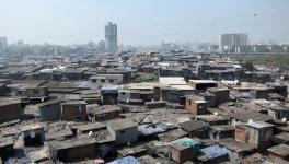
Most of the Qutb Shahi era infrastructure has been hidden within the twenty-first century urban sprawl, and the low-lying areas today are sacrificial sites for the cities’ growth project and its planners, where new infrastructure barely makes its way in. This is clearly unsustainable and calls for a change in the way city planners look at infrastructure – aiding resource-flow monitoring instead of traffic. Resilience needs to take into account the rupture in our imaginaries that not only drives this “global city” planning agenda, but increasingly alienates and marginalises slums and their inhabitants, and push them out of sight.
The City’s Resilience
Various reports have pointed out the city’s inadequate storm water drainage (SWD) system, which reportedly covers less than 30% of the city. The existing storm water drainage network in the city, which covers the major storm drains and is spread over 390 kms, is designed to handle rainfall between 15 – 20 mm per hour. It means that it can handle more than the 290 mm per day average rainfall that the city received during the floods in October.
However, because of issues of silting and deposition of solid waste, networks are clogged and fail to handle the water. Moreover, the minor drains across the rest of the city, which were proposed to be widened to handle 100 mm of rainfall per day, cannot withstand such heavy rainfall. Also, low-lying areas even defy major storm drains sometimes, since the rate of inundation varies with the intensity of the rainfall. While major areas under the GHMC limits received rainfall of above 200 mm, the outskirts – Ghatkesar received 324.8 mm of rainfall followed by 300 mm at Vanasthalipuram and 298 mm at Pedda Amberpet and Hayathnagar – which still run on the over century-old Nizam-era storm water drainage systems which are not equipped to deal with the rampant urbanisation since.
The Kirloskar Committee appointed by the then-united Andhra Pradesh government, which identified the reasons for flooding in the year 2000, noted that there were 13,500 illegal structures built on top of 390 kms of drains. This rampant construction of illegal structures is a direct result of the city planning narrative which has been adopted over the decades, one of global-city civic infrastructure development.
The 2020 Master Plan and CDA Master Plan are examples of how the civic infrastructure has been prioritised over water infrastructure and resilience measures. In fact, the 2020 Master Plan states that the cost of a new and improved drainage system have to be borne by the people living in the area and that ‘there is no way whatsoever to meet these costs.’
The focus has also been unfairly narrowed down to encroachments alone, which is far from a reality. The growth of the city and its unplanned metastasis is the problem, of which illegal encroachment is only a part.
The non-structural measures for flood resilience and preparedness are highly politicised and driven by the state’s vision and market infrastructure, further isolating city planning from its governing bodies and its socio-ecological contexts. The implementations of the Master Plans and the nature of their diverting trajectories are a testament to how the city has delineated itself from actively planning to work towards resilient measures. Today, it is forced to react to each flooding event by picking up the pieces year after year. The vision of a ‘global city’ has compromised the ability of Hyderabad to deal with extreme weather events like floods.
However, given the climate-induced extreme weather events, the question arises: should the city prepare for flooding that might occur even once in 20 years if not in a hundred years? Somewhere between preparing for urban floods every year and the deadly once-in-a-century extreme weather event, our systems of resilience need to be developed. Amid this trajectory, the city’s history of responding to disasters such as floods or even events of heat stress remains reactionary, with measures that have no lasting effect.
Unmapping resilience
We must examine what got us into this fix, and must re-examine the top-down approach of implementing a global vision for cities, which doesn’t often take into account local experiences. This approach is not just unique to Hyderabad, but is imitated across the country. This narrow global vision has brought us here. The most aggressive impacts of climate-change influenced disasters are only beginning to be felt now, in the form of floods and deadly heat waves.
In this continuing trend of climate impact, where such extreme weather events are predicted to increase in frequency, we are looking at future cities that will become un-liveable. Today’s city and its infrastructure is made of reinforced concrete structures that are short-lived and brittle, making a city’s foundation delicate by itself. And if the city’s planning allows it to flood, in addition to the impending extreme weather events, we can expect a much more decreased life expectancy for cities.
Resilience doesn’t and shouldn’t begin with extreme events – even as they are triggered by such events – it should be an increment of capacity building for existing infrastructure. The political economy of resilience needs to be exposed, where extreme weather events like heat stress need to adopt a lens of social vulnerability, one that looks for solutions beyond technological or infrastructural quick-fixes.
For instance, heat stress, when viewed through an infrastructural lens, accommodates the elite who can bypass it with cooling infrastructures, similar to how the elites during the Nizam were able to move away from the flood-prone banks of the Musi. A political economy of resilience considers the capabilities of communities that are the most vulnerable to face and adapt to such extreme events. We need to increasingly weave in local livelihoods, intersectional and disproportionate impacts of yearly weather on different communities within the city, to come up with a more robust plan for the city’s resilience.
There are avenues for the state to adopt such a vision into city planning. For instance, the Government of India has initiated the program called Atal Mission for Rejuvenation and Urban Transformation (AMRUT). It focuses on the provision of water supply, sewerage, storm water drains, green spaces and public transport in 500 cities in India. The 2019 Manual on Storm Drainage defines the norms and rules for the design of sustainable drainage systems.
The first step, however, would be for the state government to revise its 2031 Master Plan to prioritise protection and active rejuvenation of the urban commons, such farm and scrub lands, that act as natural sponges for absorbing the rain water. This would essentially mean converging and integrating the many schemes and missions that are simultaneously being implemented in the city – be it the Smart Cities Mission or AMRUT or the National Urban Livelihoods Mission (NULM) – they need to speak with each other, and more importantly, engage with the civic bodies in the cities rather than work autonomously, creating yet another parastatal body.
While the smart city missions have been made to incorporate various infrastructure changes in the city, not all of them necessarily trickle down to accommodating the needs of the urban working class, its slum dwellers, the migrants and the informal workers in terms of addressing their needs for housing, transport and livelihoods, especially those that are traditionally embedded with the commons, and have been replaced over the decades for various development projects. Such a convergence would mean integrating and mapping intersections that invariably affect each other, but it would also mean effectively managing the financing of these missions, which currently derive their funds through multiple complex sources, hindering their implementation.
In addition to ensuring that these missions and schemes don’t compete with each other for space and jurisdiction, they should also ensure that they increasingly take into account the voices of the people who have been marginalised and displaced over the decades to make space for private infrastructure and special economic zones, such as in Mumbai and Gujarat. The reiteration of the existing socio-economic inequalities and hierarchies through the smart cities missions needs to be combated. To address these concerns, there is a need for rejecting a global-vision driven solution for all cities together under the rubric of a centralised mission. There is a need for such missions be decentralised and to speak to each other to integrate technical knowledge with traditional understanding of land-use patterns.
Integrating the city’s commons into its fold of resilience measures requires an understanding of what was historically forgotten, like the abandonment of living with the Musi and its revival. This can happen through ‘unmapping’ the city and identifying its commons and evolving the current day urban planning practices to be make space for more spatial and social infrastructure within the city.
The writer is a research fellow with Tandem Research. The views are personal.
Get the latest reports & analysis with people's perspective on Protests, movements & deep analytical videos, discussions of the current affairs in your Telegram app. Subscribe to NewsClick's Telegram channel & get Real-Time updates on stories, as they get published on our website.