Indian Coastline Becoming More Vulnerable to Intense Cyclones due to Climate Change
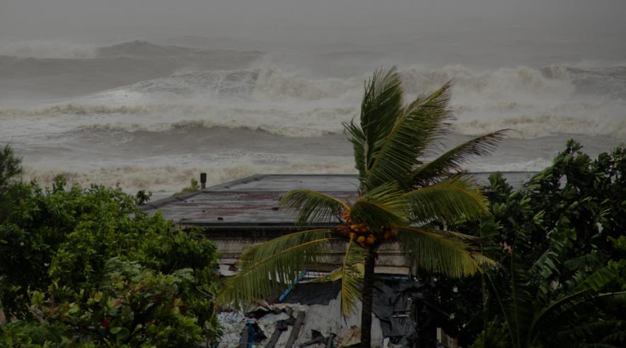
Representational Image. Image Courtesy: Flickr
Kolkata: The first cyclone of the season, Mocha, is brewing in the Southeast Bay of Bengal with favourable atmospheric conditions, which indicate a further intensification of the cyclonic storm, though the storm Mocha gave Indian territory a miss.
According to a recently published report by Climate Trends, "The month of May is conducive for cyclogenesis in the Indian Ocean. Therefore cyclone Mocha's formation is a seasonal pattern. However, what is uncharacteristic is the rapid intensification of these storms, and scientists and researchers blame the increasing global mean temperature for the changes in cyclogenesis, particularly over the Indian Ocean, 'the report pointed out."
Sugato Hazra, head of the Department of Oceanography of Jadavpur University, told NewsClick, "It is indeed alarming that due to global anthropogenic warming and rise of sea surface temperature in the northern India ocean basins (the Arabian Sea and the BOB), we are observing more number (frequency) of intense cyclones(intensity) which may increase further with the El Nino impacting us in the coming months."
Hazra also talked about how the increase in oceanic heat content now favours cyclonic storms' rapid intensification, transforming them from severe to extremely severe (like Mocha) to super cyclones (Amphan).
"Another concern is the observed global slowdown (by approximately 10%) of translational speed; that is, how fast the cyclone covers distance across the ocean and on land. Cyclone Mocha might be moving at 14-15 km/hr, compared to cyclone Sally or Dorian (2019) [8 to 2 km/hr]. Slow cyclones stay over the same area for longer and create more devastation by surges – tides or rain, as happened during cyclone Aila," he said.
Recent phenomena like twin cyclones (Asanai and Karim in 2022) and simultaneous cyclones (like Titli and Luban in 2018) in the Bay of Bengal and the Arabian Sea need much deeper investigation for a longer period to decipher any trend or pattern, Hazra told NewsClick.
Given that climate change is leading to more intense cyclones, it is time to invest in adaptation measures, such as effective early warning systems, storm shelters and appropriate infrastructure (e.g. flood resilient houses) all through our coastal area, as per Aditi Mukherji, an IPCC author, who contributed to the Working Group II Report and the Synthesis Report.
"It is important to ensure that these measures are also gender sensitive and reach marginal sections of the population who are disproportionately affected due to their pre-existing vulnerabilities," she says in the report.
Sunando Bandhopadhyay, a cyclone expert at the Department of Geography, Calcutta University, said that cyclonic storms (wind speed: ≥34 knots) inflict considerable losses in coastal Bangladesh and India.
"By building a georeferenced panel database of storm landfalls for this region, one can obtain spatial information on period-wise strike intensities," he says in an article.
Bandhopadhyay co-wrote an article titled, 'Spatiotemporal Analysis of Tropical Cyclone Landfalls in Northern Bay of Bengal, India and Bangladesh,' published in Asia Pacific Journal of Atmospheric Sciences. The paper throws important light on the landfall pattern of the Northern Bay of Bengal (NBoB) cyclones.
"Our study analysed 168 cyclone strike locations along a 1259-km impact zone for seven historical periods between 1877 and 2016. Cyclone landfall trends for this region denote a gradual reduction in storm frequencies since peaking in 1961–1980, generally in line with already established trends for the Northern Indian Ocean and Bay of Bengal basins. One notable exception for the NBoB in this is the unimodal seasonality of storm landfalls during 1877–1960, which also conformed to the bimodal regional trends in the later periods."
Bandhopadhyay also talks about how the median location of storm strikes in NBoB has shifted eastward into westernmost Bangladesh, with a particularly marked variability in location after 1960.
"Northern Odisha and West Bengal, India, experienced more cyclone strikes over the past 140 years; but the highest mean wind speeds occurred along Bangladesh's eastern coast. Storm impacts have varied considerably within and across zones; northern Odisha and the Sundarban region of West Bengal have withstood the greatest impacts. The pronounced spatial and temporal variations in cyclone impacts displayed in this study can provide valuable information for relief prioritisation and community adaptation to cyclones in the region."
In a conversation with NewsClick, Gufran Beig, an Indian meteorologist at the Indian Institute of Tropical Meteorology, Pune, said rather than the number, the intensity of cyclones is increasing in the region. He attributed it to climate change.
"This is the interchange period from La Nina condition to El Nino. El Nino is not settled till now. The frequency of cyclones is not important, what is important is their abrupt nature, and it is becoming very difficult to predict."
Researchers and scientists have been blaming increasing global mean temperature behind the changes in the cyclogenesis, particularly over the Indian Ocean. Various studies indicate how the translation speed of cyclones (the speed at which cyclones move) has decreased in the Arabian Sea. The increase in cyclonic activity in the Arabian Sea is tightly linked to rising ocean temperatures and increased moisture availability under global warming.
Roxy Mathew Koll, a climate scientist at the Indian Institute of Tropical Meteorology, has also talked about the increase in the intensity of cyclones.
"Models cannot pick up this rapid intensification of cyclones because they do not include ocean conditions properly, which is their limitation. Cyclones nowadays can retain their energy for quite a long number of days. One example of this trend was Cyclone Amphan which continued to travel over land as a strong cyclone, resulting in massive devastation. As long as oceans are warm and winds are favourable, cyclones will retain their intensity for longer."
Koll added, "The Bay of Bengal has been riding on the wave of global warming during the past few decades. Temperatures have been between 30-32 degrees Celsius in the Bay of Bengal. These high temperatures are important in intensifying cyclonic storms as they infuse more convection. This rapid intensification has recently become frequent in the Arabian Sea and the Bay of Bengal."
Human-induced climate change has led to increased cyclonic activity in the Arabian Sea and the Bay of Bengal, causing devastating natural disasters that have claimed over half a million lives worldwide in the last five decades. Rising ocean temperatures have increased evaporation and atmospheric moisture content, resulting in more frequent and severe tropical cyclones, particularly in the North Indian Ocean, where over 75% of cyclones causing human deaths of 5000 or more have occurred in the past 300 years. Coastal regions in this region are at high risk due to their dense population and vulnerability to storm surges and flooding.
A report by the Ministry of Earth Sciences (MoES) projects a rise in tropical cyclonic intensity with medium confidence and precipitation intensity due to tropical cyclonic activity with medium-to-high confidence in the North Indian Ocean basin. A comparison between pre-1950 and the post-1950 eras of pre and post-global warming, respectively, indicates that there is a rise in several severe cyclonic storms from 94 to 140 (49% increase) in the Bay of Bengal region and from 29 to 44 (52% increase) in the Arabian Sea region annually.
The MoES report has observed with high confidence an increase in the frequency of extremely severe cyclonic storms over the Arabian Sea during the post-monsoon seasons from 1998-2018. While there is medium confidence in attributing this increase to human-induced sea-surface temperature rise, the mechanism behind cyclone formation remains the same, but weather conditions are changing.
Cyclones have been intensifying at a faster pace in the recent past. The reason for this is increased sea-surface temperatures and rising ocean heat content. Earlier, the system used to take 2-3 days before forming into a tropical storm, but nowadays, the change from depression into cyclonic storm takes just a day. The atmosphere not only interacts with sea-surface temperatures but also with the entire ocean.
According to the IPCC's Special Report on Ocean and Cryosphere in a Changing Climate (SROCC), climate change is taking place due to long-lived greenhouse gases in the atmosphere that have increased the radiative forcing of the climate system. Radiative forcing happens when the amount of energy that enters the Earth's atmosphere differs from the amount of energy that leaves it.
"Energy travels in the form of solar radiation entering the atmosphere from the sun and infrared radiation exiting as heat. If more radiation is entering Earth than leaving—as is happening today—then the atmosphere will warm up because the difference in energy can force changes in the Earth's climate. The increasing Ocean Heat Content is a consequence of this energy imbalance at the top of the atmosphere, of which about 92% goes into the ocean. Primary indicators of a changing climate include an increase in the global mean surface temperature, sea level, and Ocean Heat Content."
According to the IPCC, the ocean surface temperature, on average, has increased by 0.88 degrees Celsius between 1850–1900 and 2011–2020, with 0.60°C of this warming occurring since 1980. The ocean surface temperature is projected to increase between 1995-2014 and 2081-2100 on average by 0.88 degrees Celsius to 2.89 degrees Celsius, depending on the various Shared Socio-economic Pathway (SSP) scenarios outlined by the IPCC to reduce greenhouse gas emissions and its implications on temperature rise.
Since the 1950s, the fastest sea surface warming has occurred in the Indian Ocean. The Ocean heat content has increased from 1971 to 2018 by 0.396 joules. It will likely increase until 2100 by two to four times that amount under the best-case SSP scenario and four to eight times that amount under the "business-as-usual" scenario where the least climate action takes place. As Sea Surface Temperatures and Ocean Heat Content increase, the world's oceans are projected to become warmer and wetter, leading to a rise in the available energy for evaporation. This could result in an increase in tropical cyclonic activity and rainfall, with the possibility of fewer storms but more intense ones. Category 4 or 5 storms may become relatively more common in this scenario.
Get the latest reports & analysis with people's perspective on Protests, movements & deep analytical videos, discussions of the current affairs in your Telegram app. Subscribe to NewsClick's Telegram channel & get Real-Time updates on stories, as they get published on our website.