Why Assam Really Needs to Worry About the Flood
In the mid of every year, people of Assam are fated to meet the rage of the floods. Brahmaputra and its numerous tributaries spread over the expanse of Assam, especially in the Brahmaputra valley, destroy livestock, paddy fields, animals and humans in full swing. Other major river, Barak, also inundates several places in the Barak valley, but seemingly less devastating than the Brahmaputra. Many of the tributaries originate from the hills in the nearing states like Arunachal, Manipur and Nagaland, and all of them flow down to Assam to meet the Brahmaputra. The convenient geographical location of Assam at the foot of the surrounding hills makes the numerous tributaries flow down and tour through it.
Year 2018 is also no exception. Till first week of August, Assam has witnessed two waves of floods. The first wave was in June, affecting badly hundreds of villages mainly in the districts of Sivasagar and Sonitpur. Dikhow, the tributary of Brahmaputra flowing through Sivasagar caused this havoc. Unlike this time, Dikhow normally doesn’t create penetrating destructions. Sonitpur was a different case. The Satrang tributary couldflood several villages at Gohpur area smashing the earthen embankments. Earthen embankments are one of the conventional ways of controlling rivers in Assam. The maintenance and renovations of the embankments during the dry spells are of immense importance. The mismanagement and the government’s apathy towards a serious issue like that of flood control have been reflected in these acts.
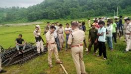
The second wave, more devastating, engulfs Golaghat, Sivasagar, Dhemaji, Lakhimpur and Darrang districts, swirling away homes, crops, lives alike. According to Assam State Disaster Management Authority (ASDMA), officials said that the floods have affected some 7,424 hectare of agricultural land, and over 26,000 people have taken shelter in 123 relief camps that are opened by the government. The possibility of an increase in the numbers cannot be denied though. Continuing with the previous years’ pattern, where a particular area is devastated enormously over other places, Golaghat becomes this year’s victim, with 116 villages under water, thousands becoming homeless. Dhansiri, the tributary of Brahmaputra flowing through Golaghat district was quite calm till July 31; nobody had even a hint of the destruction it will cause overnight. It was the release of the excess water from the Doyang Hydroelectric Power Project situated at Wokha District of Nagaland. The Doynag meets at Dhansiri and flows through Golaghat district. Controlled by North Eastern Electric Power Corporation (NEEPCO), the hydroelectric project produces 75 MW of electricity. Without giving prior notices, the water was released that made people wake up to immense difficulties.
Emotional attachment of the people of Assam to its rivers, waters and rain manifests through their presence in Asssamese literature, dance and other expressions of culture and folk. But, the recent complexities that Assam’s flood has unfolded, poses serious questions to ponder upon.
A chronic issue
Floods in Assam is a centuries-old phenomenon. But, the great earthquakes of 1897 and 1950 contributed towards the massive changes, causing the riverbed of Brahmaputra to rise its height by as much as 12 feet in several places. The one in 1950 was more significant in its impact.
People in Assam were accustomed to floods as part of their lives; also floods were welcomed for some of its beneficial consequences. Sedimentary particles carried by the flood water make the paddy fields fertile. Also, the flood gives the numerous water bodies in the state a chance for water recharge. Of course, periodical devastations occurred, for example the flood of 1985.
But since a decade or so, significant changes in the character of Brahmaputra and its tributaries can be observed. The rivers carry more of silt rather than the sedimentary particles. The areas flooded resemble a desert. Agricultural lands of thousands of hectares which get filled with the silt remain no longer fertile, and no cultivation can be done in these lands easily. Although people have come out with some remedial efforts where they do repeated rounds of washing the silt-filled land along with planting saplings of particular kind that eventually make the land a bit fertile; nevertheless their labour doubles and the gains are halved.
Unscientific models of development and unscientific ways of managing the rivers are mainly attributable factors contributing to the changing nature of the rivers. For the huge construction projects undertaken in the recent times – like building the much hyped Dhola-Sadiya bridge, the Bogibeel Bridge, the transnational highways in Arunachal Pradesh, Dibang dam, Siang dam and the most controversial lower Subansiri dam etc. – huge amount of stones and boulders had to be extracted. As stated by activists like Akhil Gogoi, for the construction of the Bogibeel Bridge alone, approximately 7.5 lakh boulders weighing thousands of tonnes were collected from the rivers both in Assam and Arunachal Pradesh. Similarly, the multipurpose project under construction in lower Dibang valley of Arunachal Pradesh will require some 193 lakh cubic metre of stones, which equals to almost 32 lakh truckload of stones. These are fulfilled by collecting boulders and big stones from the rivers both at the hills and the plains. A part of it could be met by stones from the hills alone. Geophysicists say that a huge boulder or stone contains silt or sand beneath it four times of its weight. When the boulders or stones are removed, the silt and sands become exposed and when the water level rises they flow downstream. As a consequence, the river gets filled up with silt first and thus attains levels higher than the banks. And the silt eventually gets deposited in all the areas the river floods. This has been the main cause of the silt-filled paddy fields in districts like Dhemaji and Lakhimpur of Upper Assam (North-eastern parts of Assam).
Likewise, in lower Assam, the dams and other development projects in Bhutan cause destruction at an alarming rate. The high chance of cloudburst and collapse of the dams are reminiscent of the Uttarakhand devastations. While Arunachal Pradesh is expected to become the “power house of India” with the production of 70,000 MW electricity, the possibility of this model of development bringing devastations in its wake is very high.
Just in the last year, similar wreckage was witnessed in Lakhimpur district due to the water released from the dam at the Ranganadi River up in Arunachal Pradesh. The Ranganadi dam under NEEPCO, operational since 2001, is the first run-of-the-river dam in the Northeast. This situation repeated itself after more than a decade. Ranganadi, one of the smaller tributaries of the Brahmaputra, originates in the Nilam, Marta and Tapo mountain ranges in Arunachal Pradesh. It joins the Subansiri-Brahmaputra river system in Lakhimpur district after flowing through Lower Subansiri and Papum Pare districts of Arunachal Pradesh. The dam obstructs the flow of the river and a certain amount of water is directed to a tunnel 10 km away where it drops 600 metre to another river called Dikrong. This is done to achieve the required difference of height for the turbines to move and generate electricity. Dikrong is comparatively a bigger tributary originating from Arunachal Pradesh, and joins the Subansiri-Brahmaputra river system in Lakhimpur. The diversion of water from Ranganodi to Dikrong met with the obvious consequence of drying up the river, an issue raised by the environmentalists and concerned people, much before the dam was built. Moreover, people living downstream claim that the Ranganadi riverbed has become shallow as the silt from the dam site is periodically flushed into the river. Many identify this as the foremost reason of increased flashfloods in Lakhimpur.
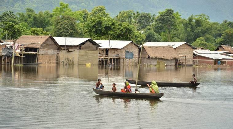
In lower Assam as well, districts like Baksa, Barpeta, Goalpara, Bongaigaon, Chirang, Dhubri, and Kokrajhar could not escape the rage of the flood. The Manas river flowing through the Manas Tiger Reserve, a world heritage site, has flooded larger areas of the reserve. Water from the dam in Bhutan at the Kurishu River, when released, causes havoc in these parts of lower Assam. Embankments in many places have been ravaged leaving lakhs affected.
In 2014, due to floods, 1,846 villages were affected, and about 1.6 million people were displaced. In 2015, the number of affected villages was 1,031 and about 1.5 million people were displaced. The numbers saw a huge jump in 2016, with 2,893 villages affected and about 1.7 million people being displaced.
This year, about 2,450 villages have been already affected by the floods, and more than 1.7 million people across the districts of Lakhimpur, Biswanath, Karimganj, Kokrajhar, among others, displaced. The monsoon season is still not over.
Insensitivity in handling the crisis
An alert, sensitive, and well-prepared spirit on part of the government in the face of imminent floods is totally absent. As mentioned earlier, even the conventional embankment system could not be maintained properly by the government agencies. The major problem in this regard has been the contractor model of construction, where the contractors primarily are concerned about their own profit, and where they get away with any corruption with their hobnobbing with the government officials and political leaders, a clear indication of crony capitalism. The Brahmaputra Board, a central government entity, was created with the purpose of developing mega plans and projects to contain the flood situation and to ensure proper management of the river system in Assam. But, no significant efforts are discernible yet.
There has never been any early alarm system developed by any government. Nor have there been any prior makeshift arrangements and prior evacuation plans of human and animal resources in the flood-prone areas. The relief efforts are largely being organised by civil society groups and people themselves. People in flood-devastated Assam have developed the habit of helping themselves during the floods. The post-flood government relief and compensation are too meager to match the loss during the floods, and this has been a norm for years. The continuation of the status quo of unscientific river management and unscientific development process will only lead to exponentially devastating the landscape of Assam.
Get the latest reports & analysis with people's perspective on Protests, movements & deep analytical videos, discussions of the current affairs in your Telegram app. Subscribe to NewsClick's Telegram channel & get Real-Time updates on stories, as they get published on our website.