After Amphan on East Coast, Cyclone ‘Nisarga’ to Hit Maharashtra, Gujarat in West
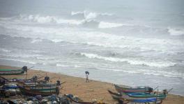
Image for representational use only.Image Courtesy : New Indian Express
Barely a fortnight after super cyclone ‘Amphan’ caused widespread devastation in West Bengal and Odisha, a severe cyclonic storm ‘Nisarga’ is approaching fast to hit parts of Maharashtra and Gujarat on India’s west coast.
According to the bulletin produced by Indian Meteorological Department (IMD), which was the latest at the time of filing this report, the Arabian Sea storm will become a cyclone by 5.30 pm On June 2. And in the subsequent 12 hours, it will take the form of a severe cyclonic storm. With this severity, ‘Nisarga’ is most likely to make its landfall near Alibag in Raigad district of Maharashtra.
According to the IMD bulletin, ‘Nisarga’ will cross North Maharashtra and South Gujarat as it makes landfall between Harihareshwar and Daman, close to Alibag. The landfall may occur on June 3. The estimated sustained wind speed is most likely to be around 100-110 km/hr with gusts up to 130 Km/Hr.
Till 8.30 am on Tuesday, it was a deep depression over the East-central Arabian Sea and was located at around 280 km West of Panjim, 450 km South-Southwest of Mumbai and 670 km South-Southwest of Surat.
The projected cyclone has developed as the deep depression has gathered strength to become a cyclonic storm. It is very likely to gather strength further and become a severe cyclonic storm by midnight today. By tomorrow, at the landfall, it will have a wind speed of 100-110 km/hr with gusts of 120 km/hr. From the night of June 3, the cyclone will start losing its strength; it will further lose its strength to become a deep depression again from around noon of June 4.
The IMD has warned that from tomorrow morning (June 3), wind with speed of 100-110 km/hr may start blowing over Mumbai, Raigad, Palghar and Thane of Maharashtra. Again, wind with speed 80-90 km/hr with gusts of 100 km/hr is likely to blow over Valsad, Navsari districts of Gujarat, Daman along with Ratnagiri, Sindhudurg districts of Maharashtra from tomorrow noon. Similarly, wind with speed of 70-80 km/hr with gusts of 90 km/hr is to blow over Surat and Bharuch districts of Gujarat and Dadra and Nagar Haveli from tomorrow noon.
Low-lying areas of Mumbai are very likely to be inundated as a storm surge of about 1-2 meters height above astronomical tide is likely to hit Mumbai, according to the IMD bulletin. Along with Mumbai, low-lying areas of Thane and Raigad districts are also projected to be inundated by storm surges. Evacuation from these low-lying areas is underway.
Extremely heavy rainfall may also occur in isolated places over Mumbai, Palgar, Thane and Raigad districts, all in the North Konkan zone, on June 3. Light or moderate rainfall is also projected in Gujarat, Madhya Pradesh and Goa.
The cyclonic storm is a double whammy for a state like Maharashtra where the number of COVID-19 cases continue to account for the highest in the country. Evacuation from the low-lying areas will pose additional difficulty.
Moreover, the cyclone may cause widespread damage in Maharashtra and also in some places of Gujarat.
Get the latest reports & analysis with people's perspective on Protests, movements & deep analytical videos, discussions of the current affairs in your Telegram app. Subscribe to NewsClick's Telegram channel & get Real-Time updates on stories, as they get published on our website.