Floods on Mars? Chinese Rover Finds a Hint
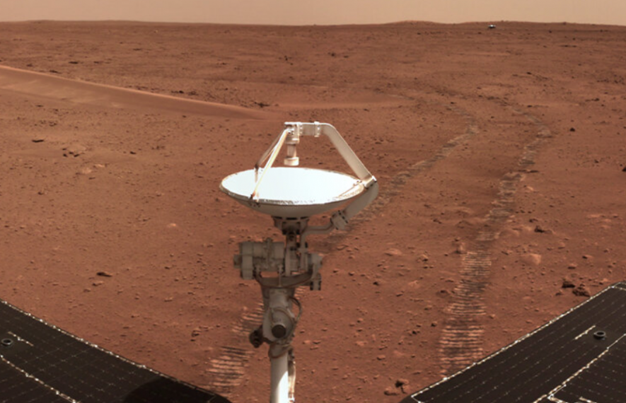
Image Courtesy: Phys.org
The Chinese Mars mission, launched two years ago, seems to have obtained some initial successes relating to its project mission. Yes, the Zhurong rover carried to Mars as part of the Tianwen-1 mission launched by the China National Space Administration (CNSA) to Mars on July 23, 2020, has found evidence of floods while peering deep under the Martian surface. These major floods probably have shaped the region.
An analysis was published in Nature on September 26, revealing the results from the radar imager on board Zhurong. Notably, the Zhurong radar imager can probe as deep as 100 metres from the surface. Commenting on the images captured by the radar, especially the depth up to which the images can be taken, Svein-Erik Hamran, a planetary scientist at the University of Oslo, said—“It is a very interesting paper, and I was particularly impressed by how deep they can see with this radar."
Hamran has experience in analysing the images deep below the surface taken by another radar system in the Perseverance rover of NASA (National Aeronautics and Space Administration).
Chinese Mars mission of Tianwen-1 aims to study the geology and topology of the planet, sample the Martian atmosphere and examine indications of the presence of water on the planet. The rover drove onto the Martian surface on May 22 of, 2021. Earlier, Zhurong sent back a new set of images from Mars that included a selfie. It had sent its first images of Mars back in May after landing a few days earlier. The new pictures included a 360-degree panorama of the landing area. According to the Chinese news agency Xinhua, the panorama photograph was stitched together from a number of images Zhurong captured after it had landed and began to move in the area.
This time, Zhurong's radar imager sent images, not from the surface but beneath, revealing information about the possible presence of water on the red planet.
Zhuring’s landing site, the Utopia Planitia, which is a vast plain in the northern hemisphere of Mars, appeared puzzling to scientists. Some of them put forward the theory that ice and water were once present there and shaped the landscape of the region. In fact, observations from space bolstered this theory, which identified sedimentary deposits suggesting the region to be either an ancient ocean or submerged in hue floods. Alongside, geological features such as pitted cones are similar to structures formed by water or ice. In addition, researchers, in their analysis of infra-red images of the site, found hydrated minerals, which could have been possible when groundwater rose through rocks or melted ice.
The initial observations opened up another possibility that the region could have been covered in lava. The volcano Elysium mons to the east of the landing site, along with other such volcanic activities, could have covered the region with magma. Now, with the radar imageries, scientists attempt to understand what actually happened and whether ice or water is still hiding below the rocks.
"We want to know what is going on beneath the surface," commented Liu Yang, a planetary scientist at the National Space Science Center in Beijing and a co-author of the Nature publication.
The ground penetrating radar on Zhurong transmits high-frequency radio waves penetrating through the surface to a depth of 3 to 10 metres, along with low-frequency waves that can penetrate even more profound, up to 100 metres. The study authors analysed the low-frequency data of about three and a half months in over 1,000 metres of the Martian surface as Zhurong travelled south of its landing site. The radar signals get reflected back from the materials under the surface and thus reveal their sizes.
The radar signals did not reveal any trace of water up to 80 metres beneath; nevertheless, it could detect two layers having interesting patterns. In one of the layers, which is 10 to 30 metres deep, the scientist team found that the reflection signals strengthened with depth.
According to the researchers, this could be due to the presence of giant boulders at the base of the layer while smaller rocks settle on the top. Notably, the reflected signals' strength indicates the size of the object—the more robust the signals larger the objects are. Again, the researchers found an older and thicker layer between 30 to 80 metres down to have shown similar patterns.
The older layer, according to them, could be the result of flooding that carried sediments to the region around three billion years back. The upper layer could also be the result of another flood, but more recent, some 1.6 billion years ago.
However, this is just an initial analysis. The radar data alone is not sufficient to say with confirmatory words whether the rocks were sedimentary or volcanic. Sedimentary rocks indicate the presence of water. There are possibilities that these could have resulted from volcanic eruptions as well. More radar data, which is yet to come out, could reveal the details, according to Ling Chen, a co-author of the Nature paper.
Get the latest reports & analysis with people's perspective on Protests, movements & deep analytical videos, discussions of the current affairs in your Telegram app. Subscribe to NewsClick's Telegram channel & get Real-Time updates on stories, as they get published on our website.