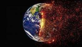
El Nino Around Corner, Dry and Warmer Days Ahead: WMO
Image Courtesy: WMO
Some changes in the Pacific Ocean, thousands of kilometres away from India, may impact weather conditions here. In fact, the temperature of Pacific Ocean’s water determines weather conditions of world’s tropical areas, spanning the equator, parts of North America, South America, Africa, Asia and Australia.
One such Pacific event is the El Nino and the WMO (World Meteorological Organisation), in its latest update said that El Nino was developing fast. The El Nino period is usually hotter, including heatwaves and drought in some parts while rainfall in others. El Nino results in increased rainfall in areas of South America, the US, Central Asia etc., while it may bring in droughts in South Asia, Australia, Indonesia.
The latest WMO update suggests there is 60% chance that Pacific conditions turn into El Nino from ENSO neutral during May-July. Again, the chance of transiting to El Nino increases further to 70% during June-August and rises to 80% during July-September. However, “there is no indication of the strength or duration of El Nino”, the WMO update said.
There exists a periodic climatic condition that depends on the temperature of water of the central and eastern tropical Pacific Ocean. The surface water of a large area of the tropical Pacific moves in cycles between cool and warm by about 1 degree Celsius to 3 degree Celsius in comparison to normal. These warm and cool cycles can range from three to seven years.
This alternating cool and warn pattern is known as the ENSO (El Nino Southern Oscillation), which impacts weather conditions of tropical areas of the world. The ENSO cycle consists of La Nina and El Nino— the cooler phase is La Nina, while warmer phase is El Nino.
The ENSO cycle shifts from one phase to the other with a neutral phase where there is neither El Nino or La Nina and the surface temperature of the tropical Pacific is nearly close to the average. The WMO update suggests that the preceding La Nina phase has ended (in March) and there has been a neutral period, which is fast transiting to the El Nino phase.
The worry is that the already warm Earth due to man-made climate change, may produce warmer days as far El Nino exists, as it is the hotter phase of the ENSO cycle. In contrast, during the period of La Nina, a relatively cooler weather is witnessed. However, things may not appear as such, thanks to global warming.
Expressing concern, WMO secretary general Petteri Taalas said in statement, “We just had the eight warmest years on record, even though we had a cooling La Niña for the past three years and this acted as a temporary brake on global temperature increase. The development of an El Niño will most likely lead to a new spike in global heating and increase the chance of breaking temperature records.” This is indeed worrisome.
We saw a recent example of this. The year 2016 was the warmest year in record, according to WMO’s State of Global Climate Reports, 2016. This could have happened due to the combination of primarily two factors—a very powerful El Nino event and global warming due to greenhouse gases. However, the effect on global temperature generally wanes the following year of an El Nino developing, says WMO. If so, we will witness calming of the temperature by 2024.
On the fast developing El Nino and its ramifications, Taalas said, “The world should prepare for the development of El Niño, which is often associated with increased heat, drought or rainfall in different parts of the world. It might bring respite from the drought in the Horn of Africa and other La Niña- related impacts but could also trigger more extreme weather and climate events. This highlights the need for the UN Early Warnings for All initiative to keep people safe,”
SKYMET PREDICTS BELOW NORMAL MONSOON
It is worth mentioning here that a month ago, Skymet, a private weather forecasting company, forecast that India this year would have below normal monsoon rainfall. The Skymet report suggested that the Northern and Central parts of the country were at a higher risk of being rain deficient. It said Gujarat, Madhya Pradesh and Maharashtra would receive inadequate rain during the peak months of July and August. Similarly, Punjab, Haryana, Rajasthan and Uttar Pradesh would also see ‘less than normal’ rain this monsoon.
The Skymet report also mentioned the developing of El Nino conditions over the tropical Pacific as a reason for the rain-deficient monsoon this year in India.
However, the government-owned India Meteorological Department has predicted a normal monsoon. Skymet predicted 94% rainfall of the long period average (LPA) with an error margin of +/-5%, while the IMD predicted a 96% rainfall of the LPA (with error margin +/-5%) during the same period.
Get the latest reports & analysis with people's perspective on Protests, movements & deep analytical videos, discussions of the current affairs in your Telegram app. Subscribe to NewsClick's Telegram channel & get Real-Time updates on stories, as they get published on our website.