Severe Cyclonic Storm Mocha Likely to hit Cox's Bazar, World's Largest Refugee Camp in Myanmar
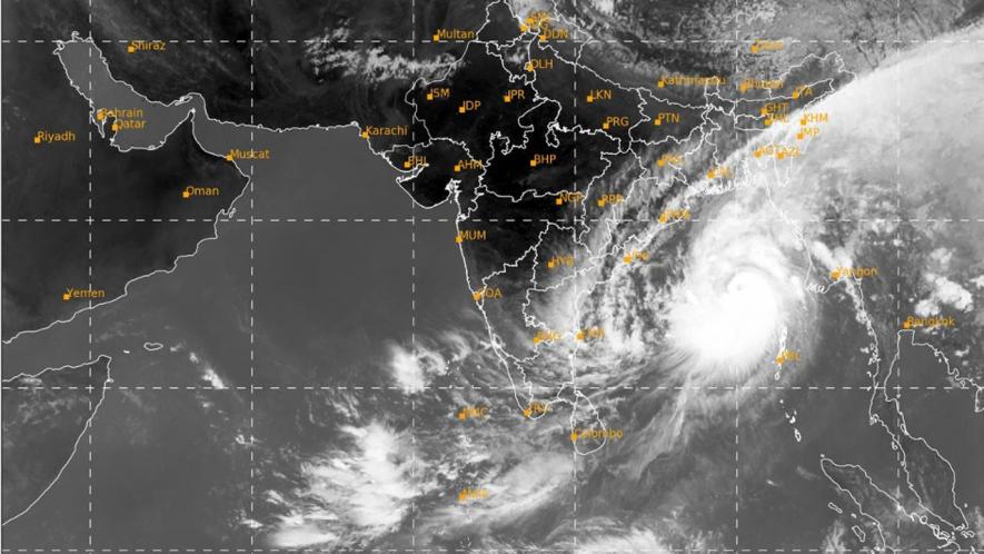
Image courtesy: The Weather Channel
Patna: A severe cyclonic storm, Mocha, is set to badly hit thousands of vulnerable people at Cox's Bazar, the world's largest refugee camp, as well as the internally displaced camps in Rakine state, Myanmar, warned scientists on Sunday.
Experts at the Kathmandu-based International Centre for Integrated Mountain Development (ICIMOD) fear that Mocha could be the most devastating storm to hit Myanmar since the catastrophic Nargis in 2008, which claimed the lives of 100,000 people. Moreover, it poses a significant threat to Bangladesh, potentially becoming the most powerful storm the country has faced in two decades.
In a statement, Mandira Singh Shrestha, Senior Water Resources Specialist at ICIMOD, expressed deep concern, stating, "It is the most vulnerable communities in our regional member countries that are likely to bear the brunt of Storm Mocha."
According to ICIMOD, the extremely severe cyclonic storm is hours away from making a landfall on the coasts of Bangladesh and Myanmar. Of particular worry is the potential impact on Cox's Bazar in Myanmar, where an estimated six million people are in dire need of humanitarian assistance.
ICIMOD has been collaborating closely with meteorological agencies from its member countries, leveraging their expertise in the development and application of advanced tools for weather analysis, seasonal forecasting, and climate projections. Through these collaborative efforts, ICIMOD has been developing and deploying tools and services aimed at enhancing local resilience to extreme weather events.
According to the latest advisory from the India Meteorological Department (IMD), Mocha is projected to cross the Rakhine Coasts between Cox's Bazar, Bangladesh, and Kyaukphyu, Myanmar near Sittwe. Expected to hit as an Extremely Severe Cyclonic Storm in the noon, the system is then forecast to move North-Northeastward towards Chin State, Magway, Sagaing Regions, and Kachin State as a Very Severe Cyclonic Storm.
According to an IMD briefing, Mocha is expected to bring sustained wind speeds of 180-190 kmph, with gusts reaching 210 kmph, narrowly missing the threshold for a Category 5 storm. The Washington Post reports that areas near the landfall zone should prepare for "disastrous winds, extreme surge and rainfall, as well as a freshwater flood threat."
In anticipation of the storm's impact, a storm surge of 3-3.5 meters above ordinary tide levels is likely to inundate low-lying areas along the North Myanmar and southeast Bangladesh coasts, accompanied by massive waves reaching up to 7 meters. The cyclone's eye, measuring 35 kilometres, will have a particularly devastating impact within a 40 kilometres radius.
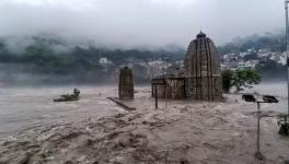
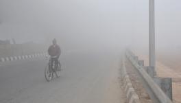
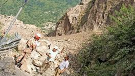
In addition to the immediate threats posed by Mocha, heavy rainfall from the storm is expected to persist throughout the region, increasing the risk of river flooding and landslides in North-East India and the Tibet Autonomous Zone of China.
The United Nations Office for the Coordination of Humanitarian Affairs (UNOCHA) has expressed grave concern for the storm's potential impact on vulnerable and displaced communities, including the 232,100 individuals residing in low-lying internally displaced camps in Rakhine state.
While the direct link between climate change and the frequency of hurricanes, storms, and cyclones remains uncertain, it is widely acknowledged that global warming contributes to the intensification of these weather events. Warmer sea surface temperatures provide increased energy.
Last year, the Bangladesh Meteorological Department (BMD) officially launched a High-Impact Weather Assessment Toolkit (HIWAT), a customised weather research and forecasting model developed by NASA’s Marshall Space Flight Center. It provides forecasts for various weather parameters like rainfall, hailstorm, temperature, and even lightning 54 hours in advance.
BMD professionals have received training to help them independently operationalise and use HIWAT to simulate extreme weather hazards, issue forecasts, and effectively manage the system.
The tool currently covers areas of Bangladesh, Bhutan, Nepal, and Northeast India. In collaboration with NASA and USAID, ICIMOD's SERVIR-HKH initiative further customised the tool for the region, and developed specialised country-level visualisation systems for Nepal HIWAT-Nepal, Bangladesh HIWAT – Bangladesh, and Bhutan HIWAT – Bhutan.
Get the latest reports & analysis with people's perspective on Protests, movements & deep analytical videos, discussions of the current affairs in your Telegram app. Subscribe to NewsClick's Telegram channel & get Real-Time updates on stories, as they get published on our website.