Typhoon Mangkhut More Destructive and Higher in Intensity than Florence?
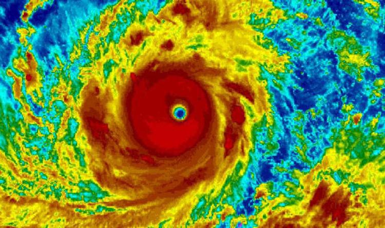
Two deadly storms have hit two opposite sides of the world, Hurricane Florence on the east coast of the US, and Typhoon Mangkhut in eastern Asia. Between the two, Mangkhut is more powerful in its strength with winds of 265 km/hr, whereas Florence has a wind speed of 145 km/hr. Mangkhut is categorised as a category 5 typhoon which is the highest in the scale, while Florence qualifies for a category 1 hurricane, the lowest in the scale.
A comparison of the areas engulfed by the two storms shows that Mangkhut dwarfs Florence. Mangkhut stretches a swathe of 325 miles from the centre, whereas Florence covers 195 miles. Mangkhut first hit northern Philippines at the province of Luzon on Saturday, and continued towards Hong Kong and southern China. The insurmountable devastation has made many parts of Philippines, Hong Kong and China almost paralysed.
The source of origin of any storm also determines the intensity of it. Generally, the Western Pacific region has a higher chance of a storm metamorphosing into a stronger typhoon. The 65 years’ data on storms has shown that the Western Pacific has three and a half times more storms that have the potential to reach the major typhoon strength with wind speed of 111 km/hr.
Mangkhut was formed towards the south of the Western Pacific, where the water temperature is higher and it remained in the south. This gave the typhoon opportunities to gather its enormous strength. Warmer sea water makes air warm and moisture filled, which makes storms stronger. On the other hand, Hurricane Florence was formed near Africa and by the time it hit the land it had already moved out of the tropical region. The dry and colder air in the higher latitude region made the hurricane lose its strength.
The Philippines is more prone to be hit by typhoons than North Carolina in the US. Philippines gets hit almost every year by devastating typhoons. Typhoon Haiyan of 2013 still haunts one’s memory for huge destruction that killed some 7,300 people and left more than 5 million displaced.
People that face greater turbulence of the storms generated in the Western Pacific are economically more vulnerable. This means that the destruction caused by these storms will lead to bigger economic burdens to be carried by the people in these regions.
Climate Change is Going to Aggravate Storm effects in the Future
While tropical storms are not very abnormal phenomenon, the severity and enormity of these storms are going to witness an absolute high in the times to come. Man-made climate changes, as the climate scientists say, are mainly responsible for the more ravaging impacts of the storms.
Hurricanes and typhoons are both tropical storms differing in their names with respect to the places of their origin. Storms originating over the Atlantic and north-eastern Pacific Ocean are called hurricanes and those originating over the north western Pacific are called typhoons.
Tropical storms are formed over the ocean and the impact of climate change on them can be understood from the process of its formation. As the sea surface temperature rises in summers, warm, moist air from the surface of the ocean rises upwards and creates a low pressure area. The neighbouring area, having a high air pressure, pushes the air towards the low pressure area and makes the air swirl around it. But not all of these develop into typhoons or hurricanes.
Warmer sea surface with global warming will intensify the process of typhoon formation. Warmer sea surface will cause more evaporation of water from the surface, and more moisture and clouds will be formed in the process. This increased evaporation will cause greater low pressure and will provide more energy to the storms. The greater the energy of a storm, the higher will be its speed and have a more devastating impact. The rain that accompanies a storm will also have greater intensity as more clouds are formed from warmer sea surface.
The laws of thermodynamics say that heat only flows from an area with greater temperature to an area with lower temperature. These laws also govern storm formation. As the northern hemisphere starts cooling in the late summer, the warmer sea surface will transfer heat more rapidly towards the hemisphere and this process will contribute to the formation of storms with greater energy. As a result stronger typhoons are more likely to occur during September, scientist Xie explains.
Get the latest reports & analysis with people's perspective on Protests, movements & deep analytical videos, discussions of the current affairs in your Telegram app. Subscribe to NewsClick's Telegram channel & get Real-Time updates on stories, as they get published on our website.