How Cyclone 'Asani' Wreaked Havoc and why Annual Floods Devastate Assam
In the last three years, India has been pounded by at least 19 cyclones, and 'Asani' was just another storm to lash Assam this year. Every year during the monsoon, the Northeastern state is prone to flooding. Thousands of families are uprooted from their homes each year and forced to seek shelter in the neighbouring states. Natural disasters hit at least 25 of the state's 33 districts each year.
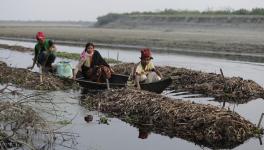
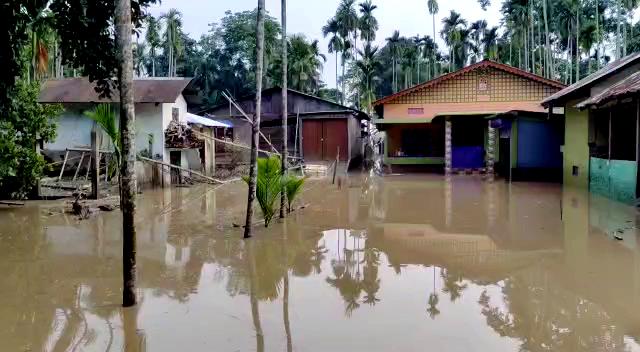
According to the State's Disaster Management Authority, at least 30 people died due to the flooding caused by cyclone Asani. According to the administration, 956 of the 1000 communities affected are still in underwater regions.
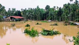
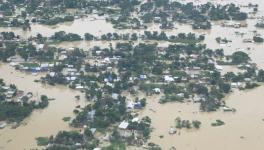
These floods occurred before the ones expected in the upcoming monsoon season and affected almost five lakh people, about a fifth of them children. Many say they did not anticipate this year’s floods and they were the worst they have seen. The inhabitants now face a dismal future with roads, schools, and residences inundated and connectivity gone.
The floods began on May 15 when the state's water inspection department failed to draw safeguards and open the sluice gate, according to Muzanil, a resident of Jalalpur village in the Cachar district. "People have lost their land, their houses, and all they had to earn a living," he said.
Muzanil added, “During monsoon season, we normally anticipate flooding and avoid farming. This was unprecedented, and our people have suffered greatly as a result."
"The issue is that the government just provides relief measures, which means that they can't even help control the floods and can only deal with the aftermath," said a geologist from Guwahati University while speaking to NewsClick on the condition of anonymity.
Shamsul, who owns a small business in Cachar's Jalalpur village and works with NGOs that provide help to the afflicted, said at least 250-300 individuals sought safety in a nearby government school after their homes were flooded by rain and went under three-feet deep water. "Had it not been for the NGOs, our people's difficulties would have risen much more, and the number of people missing and dead would have skyrocketed," he told NewsClick.
Floods occur on a yearly basis throughout the state, and the relief methods are only temporary. According to figures released by the Assam government, floods affect over 40% of the state’s land each year, with the average loss paid by the state owing to floods totalling around Rs 200 crore each year.
The Brahmaputra River is a major cause of annual flooding. Some portions of the riverbank land get eroded every year due to the river's aggressive flow. As per data available with the state government, 4.27 lakh hectares or nearly 8% of land has been eroded due to the Brahmaputra since 1950.
According to the Assam government, the state's flood-prone territory is 31.05 lakh hectares out of a total of 78.523 lakh hectares, which implies that roughly 40% of the state's land is prone to flooding. Apart from Assam's natural terrain and heavy yearly rainfall, the disastrous floods that devastate the state are caused by various man-made and natural factors.
Assam has a huge network of waterways, including the Brahmaputra and Barak Rivers, as well as over 50 tributaries that feed them. River water is also delivered to Assam from neighbouring states like Arunachal Pradesh and Meghalaya. Due to cloud bursts in Meghalaya's catchment regions, the south bank tributaries of the Brahmaputra in lower Assam saw flash floods of great extent in 2004 and 2014. In 2011, a similar situation occurred in Arunachal Pradesh, exacerbating the floods in Assam.
Brahmaputra's bank erosion is one of the main reasons Assam floods every year. It comprises the erosion of soil, silt, or rock pieces along the banks caused by strong water flow. The river's breadth grows due to erosion, and its path shifts. Due to bank erosion, the river's width has increased to 15 kilometres in certain areas, making it India's largest river. It is estimated that almost 8,000 hectares of land are lost to erosion each year. The results of several studies conducted at various times paint a frightening picture of Brahmaputra's expansion.
The first survey of the Brahmaputra conducted between 1912-28 showed its area as 3870 square km; the second survey between 1963-75 showed the width to be 4850 square km, and the latest one in 2006 showed the width at 6080 square km. This rate of increase in width of the severely aggressive river has had a massive impact on the state’s livelihood. The Brahmaputra Board proposed dams and reservoirs to help Assam cope with floods in 1982. While dams are intended to control water flow, they can also exceed the capacity of downstream waterways, proving to be a double-edged sword.
The speedy melting of the glaciers due to global warming coinciding with the monsoon downpour further intensifies the flow of water, raising the water levels. Adding to this are several manmade reasons like the government-built embankments, which are of no use and fall apart every year, resulting in rising water levels.
Arun, a farmer and owner of a grocery shop, lives in Radhanagar village in the Hojai district. Due to the flooding, he has lost both of his work. The majority of the residences, including his, were destroyed. On May 18, when the weather had improved, the rescue crew arrived at his home. "We weren't sure if we were going to live," Shiva said. “I work as a farmer. Due to the catastrophic floods, all of my crops have been ruined. There's no food, and there's no way to make money,” he lamented.
According to the impacted farmer, they were saved on the day the rescue operations began. “Water was up to knee length, there had been no electricity for at least five days, and we were absolutely unsure about how the rescue operations would reach us, but they did,” said Arun.
A local journalist who wished to remain anonymous drew NewsClick’s attention to the problems from the government’s end. He alleged that most of the measures taken by the government had failed to provide any kind of immunity from floods. Moreover, he highlighted how the flood prevention equipment had little effect due to little attention paid to them in recent years. He narrated, "There are at least ten sluice gates from Cachar Hills to Barak Valley region. Out of those, nine did not even open in need of the hour. It is near the BSF camp, and while they tried to open the gates, they failed since those had not been repaired or opened in the past 12-13 years. Further, several embankments created in the region have not been mended in the past six-seven years. This behaviour has led to floods and mudslides in the areas that faced no impact of floods in the past 150 years.” He further claimed that the govt had not lived up to its promises. He said, “When this government came to power, they swore not to build any dams or even support any dam projects. However, little has been done for the cause by them.”
In Dima Hasao District, Assam lost the New Haflog Railway Station. Rains continued to fall in the region, causing rail and road services to be disrupted. The train station was engulfed in mud after a series of mudslides. The Barak valley, whose only connection to the Northeast was the station, is now cut off from the rest of the world. Unplanned development has been blamed by activists for the closure of the Haflong Railway Station.
Activists claim that the road link projects were launched without a thorough examination of the soil composition and carrying capacity in the affected areas. Before the development of new road link projects, the Dima Hasao district has never seen a mudslide. The Assam Railway Department estimates that restoring service for the station will take at least two months.
"It was the most magnificent train station we had ever seen. Seeing it in the debris pinched all of us," said Zaheer, a Dima Hasao resident. "Barak Valley has now lost entire communication with the North East," he said, adding, “The government is to blame. This would not have happened if they had taken care of and prepared for everything properly earlier. Floods may be unprecedented, but development certainly is not.
The writer is an Odisha-based freelance journalist. She writes on education, health and about politics.
Get the latest reports & analysis with people's perspective on Protests, movements & deep analytical videos, discussions of the current affairs in your Telegram app. Subscribe to NewsClick's Telegram channel & get Real-Time updates on stories, as they get published on our website.