ICIMOD Study Says Chamoli Disaster Was Triggered by Massive Landslide
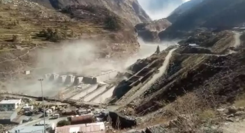
Image Courtesy: Down to Earth
After conducting a thorough study on the Chamoli flash flood disaster in Uttarakhand, scientists and experts of the eight member countries of International Centre For Integrated Mountain Development (ICIMOD) have concluded that the catastrophe was not caused by a Glacial Lake Outburst Flood (GLOF), but was triggered by a massive rockslide just below Ronti peak in the Nanda Devi massif. It happened approximately 22 km upstream of the Rishi Ganga hydropower project (HPP) site. The energy of the fall melted the ice, which then became the source of the flood. This remobilised the debris and ice on the valley floor deposited by previous events, pushed the stream water and created an excessive flood wave.
A strong Western disturbance passed across Kashmir and Northwest India between 4 and 6 February, 2021. It was fully charged with convective instability that, ICIMOD scientists speculate, may have contributed to the heavy precipitation and the disaster.
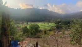
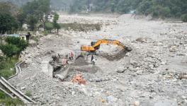
Disaster struck Uttarakhand’s Chamoli District on February 7, when a massive flash flood ravaged through the valleys of the Rishi Ganga, Dhauliganga and Alaknanda rivers. More than 70 people have been confirmed dead and another 134 people were reportedly missing. The flood swept away the unfinished Tapovan Vishnugad Hydropower project and inflicted substantial damage on the Rishi Ganga Hydropower project.
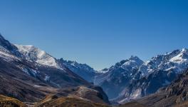
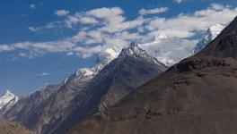
The region consists of high mountain ranges with steep topography, including the second highest peak in India, Nanda Devi, at 7,816 meters above sea level (masl).
The Chamoli flood was not much far off, just 60 km northeast of where the devastating Uttarakhand flash flood occurred in 2013. It took place near the Rishi Ganga river on the Northern side of Nanda Ghumti peak (7050 masl), in Tapovan area of Chamoli district . The Rishi Ganga is a tributary of the Dhauliganga river, which originates at the Raikhana Glacier (5375 masl) to the North and meets the Alaknanda River further downstream. The high-altitude area consists of glaciers and snow peaks which melt during the spring and summer season and provide meltwater to downstream areas. Because of the perennial sources of water and steep topography, hydropower plants have been constructed across many tributaries. Presently, about 3900 MW of hydroelectricity is generated in Uttarakhand, out of its estimated hydropower potential of 20,000 MW, with several under-construction projects expected to add another 3200 MW.
Scientists have also probed the climate change angle connected to the entire tragedy. It was found that maximum temperature in the Chamoli area has increased at the rate of 0.032o C per year between 1980 and 2018 . Furthermore, January 2021 was the warmest January recorded in Uttarakhand in six decades. The dramatic reduction in snow cover was noted between February 6 and February 10. The scientists are of the view that while a hazard event like the flood at Chamoli cannot be directly attributed to climatic changes, the increased thaw-freeze cycle of permafrost could have partially contributed to the event.
The event and related debris flow/flood caused damage to four hydropower projects along the Rishi Ganga, Dhauliganga and Alaknanda river path The Rishi Ganga Hydropower project (13.2 MW) near Raini village, located 14 km downstream from the impact site (Figure 10), was the first to be hit by the debris after the rockslide. The unfinished Tapovan Vishnugad Hydropower project (520 MW), 8 km downstream from the Rishi Ganga Hydropower project, was the second hydropower plant ravaged by the flood. The diversion dam of this run-of-the river type project faced massive damage from sedimentation and the dam was filled with debris, which can be seen in the remote sensing images taken before and after the event.
The ICIMOD study also mentions the IPCC 2019 report which reveals that the mountainous regions are exposed to many cryosphere- (earth’s surface where water is frozen solid) related hazards. The frequency, magnitude and areas of these hazards are projected to change as the cryosphere continues to decline. The escalation of cascading hazards to a cascading disaster is a common phenomenon observed in the Hindu Kush Himalaya region. One of the prominent recent examples is the Uttarakhand flood of 2013, which started with heavy rainfall and caused a chain of events including landslides, flash floods, and the Chorabari lake outburst and debris flow, which killed more than 6,000 people and damaged roads, bridges, and other infrastructure.
Also read: Handling of Electronic Evidence by Agencies a Perversion of Criminal Justice: CCG
Similar hazard events in combination with other geophysical processes can damage several hydropower stations. There are around 105 existing hydropower projects (≥ 40 MW) with an installed capacity of 37 GW, 61 projects (≥40 MW) currently under construction (39 GW) and 890 projects (≥10 MW) in various stages of planning (242 GW) in the Karakoram-Himalaya region. Most of the existing hydropower projects were built in the past two to three decades, mainly starting from the downstream sections. Now these projects are gradually moving upstream where the exposure to mountain hazards is high. The chances of multiple hazards happening in combination and more frequently with the cascading effects can create compounding impacts on the system. Hydropower projects are particularly at risk because of the proximity of their infrastructure (such as diversion dams/reservoirs) to the river network where water-related hazards occur. Many hydropower projects have been damaged by events like the Chamoli floods. Scientists are also of strong opinion that the hydropower infrastructure also impacts the local environment, causing changes in natural flow regimes and environmental flows, alteration of aquatic ecosystems, and deterioration of water quality, among others.
The rockslide-triggered flash flood in Chamoli is one of the many possible hazards in the Hindu Kush Himalaya mountains. Mountain hazards like glacial lake outburst floods, torrential floods, debris flows, landslides, and avalanches, especially caused by the coupling of avalanches, glacier movement, snow melt, and extreme precipitation are common in this region.
Study calls for the need of sustained investments from national agencies for establishment of environmental monitoring, analysis and information systems to work jointly on such natural disasters. Collaborative efforts between institutions within the region and with international institutions can help in building robust systems and capacity within the Himalayan region.
The Hindu Kush Himalaya is a multi-hazard environment. Human interference in the mountain environment is rapidly increasing as well. Mountain settlements are increasing in size and land use patterns are changing. Infrastructure such as roads and hydropower projects are rapidly penetrating mountain landscapes. The interplay between natural hazards with human settlements and infrastructure is an important aspect, which can significantly escalate the impact of events like the Chamoli flood. Disaster risk management therefore needs to incorporate a multi-hazard risk assessment approach.
On the environmental front, hydropower development impacts environmental flows, water quality, and the health of aquatic and terrestrial ecosystems. At the same time the physical environment poses many challenges to hydropower development and sustainability. Climate change-related flow variations, extreme events, erosion and sedimentation, and GLOF/LDOFs, are some of the environmental challenges to such projects.
Among the recommendations listed in the ICIMOD study, scientists say that a comprehensive sustainability framework considering financial, environmental and social sustainability can help make hydropower a viable energy option. For the sustainability of hydropower in the Hindu Kush Himalaya region, environmental threats need to be minimised by mitigating risk through both structural (e.g. erosion protection work) and non-structural measures (e.g. operating rules). Besides this, mitigating the risk of climate change and flow variability is of paramount importance for future energy security for which a better understanding of future climate projections and water availability is needed. That understanding can be reflected in the design and location consideration of future hydropower projects in the region.
Seema Sharma is a Chandigarh-based independent journalist who writes on environment, wildlife, climate change, social and gender issues.
Also read: Dhobi Ghat Paathshaala: Promise of Education at the Site of Demolition
Get the latest reports & analysis with people's perspective on Protests, movements & deep analytical videos, discussions of the current affairs in your Telegram app. Subscribe to NewsClick's Telegram channel & get Real-Time updates on stories, as they get published on our website.