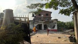
Dibang Project Cleared by Modi’s Cabinet, Concern for Assam?

Image Courtesy: Open Democracy
The Prime Minister Narendra Modi-led cabinet committee on economic affairs on Wednesday (July 17) approved a fund of Rs 1,600 crore as a pre–investment activities as well as various clearances required for the 2,800 megawatt (MW) Dibang multipurpose project. It is to be the country’s largest hydel project with the highest dam at 278 metres.
However, the project is yet to get the stage-II forest clearance. Situated on the Dibang River near Munli Village in Lower Dibang Valley district of Arunachal Pradesh, the total land required for the project is over 5,000 hectares. Out of this, more than 4,000 hectares belong to state forest, 700 hectares are community lands without forest cover and 70 hectares of land is being used for wet rice cultivation.
The total estimated cost of the Dibang project is over Rs 28,000 crore and is expected to be completed within nine years after the green signal from the government. Arunachal Pradesh will get 12 % free power from the project.
But Assam has seen huge protests against big dams in the Northeast. Due to such protests, the lower Subansiri Hydro Electric Project has been stalled since 2011. Several organisations like the All Assam Students Union (AASU) and Krishak Mukti Sangram Samiti (KMSS) have been registering vehement opposition to big dams in the Northeast.
Also read: Trans-Boundary Rivers, Heavy Rains and Breaching Dams
KMSS leader Akhil Gogoi, in a recent press conference in Guwahati, said,“What will happen to the people living in downstream areas if water is released from the 278-metre dam? Forget about that, what will happen if the dam breaks?” Akhil Gogoi also criticised the Centre’s move for not engaging in any talk with the people of Assam. “On December 11, 2014, a meeting was held among the Centre, state government, National Hydroelectric Power Corporation and various organisations on the Lower Subansiri Hydro Electric Project. The meeting, chaired by then Union power minister Piyush Goel and then sports minister Sarbananda Sonowal, decided that construction of no dam would be approved without a downstream impact study,” he added.
AASU president Dipankar Nath also raised similar apprehensions, saying, “There cannot be a project that throws the lives of people living in downstream areas into uncertainty. We demand a downstream impact study of the project.”
Why Assam Fears Big Dams
Arunachal Pradesh is expected to become the “power house of India” with the production of 70,000 MW of electricity, through dams. Assam is situated in a geographical location where the rivers flowing through Arunachal, Nagaland, etc. ultimately flow down to it only to get merged with the Brahmaputra. Any extra water released from the dams uphill can lead to enormous inundation of Brahmaputra valley. This is the most serious concern of the people of Assam.
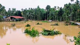
This year, 30 out of 33 districts of Assam have been devastated by floods and more than 50 lakhs people have been affected. In this year’s floods too, the releasing of water from dams uphill are being seen as the main cause behind the flooding of many districts of upper Assam (north-eastern part of Assam).
However, this is not the first time. For example, in last year’s floods, release of excess water from the Doyang Hydroelectric Power Project situated at Wokha district of Nagaland created havoc in Golaghat district. The Doyang river meets the Dhansiri river and flows through Golaghat district. Controlled by North Eastern Electric Power Corporation (NEEPCO), the hydroelectric project produces 75 MW of electricity. Without giving prior notices, the water was released that made people wake up to immense difficulties.
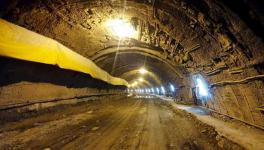
In the floods of 2017, similar wreckage was witnessed in Lakhimpur district due to the water released from the dam at the Ranganadi river in Arunachal Pradesh. The Ranganadi dam under NEEPCO, operational since 2001, is the first run-of-the-river dam in the Northeast. This situation had occurred after more than a decade. Ranganadi, one of the smaller tributaries of the Brahmaputra, originates in the Nilam, Marta and Tapo mountain ranges in Arunachal Pradesh. It joins the Subansiri-Brahmaputra river system in Lakhimpur district after flowing through Lower Subansiri and Papum Pare districts of Arunachal Pradesh. The dam obstructs the flow of the river and a certain amount of water is directed to a tunnel 10 km away where it drops 600 metre to another river called Dikrong. This is done to achieve the required difference of height for the turbines to move and generate electricity. Dikrong is comparatively a bigger tributary originating from Arunachal Pradesh, and joins the Subansiri-Brahmaputra river system in Lakhimpur. The diversion of water from Ranganodi to Dikrong met with the obvious consequence of drying up the river, an issue raised by the environmentalists and concerned people, much before the dam was built. Moreover, people living downstream claim that the Ranganadi riverbed has become shallow as the silt from the dam site is periodically flushed into the river. Many identify this as the foremost reason of increased flashfloods in Lakhimpur.
Also read: Why Assam Really Needs to Worry About the Flood
In lower Assam as well, districts like Baksa, Barpeta, Goalpara, Bongaigaon, Chirang, Dhubri, and Kokrajhar have not escaped the rage of the flood. The Manas River flowing through the Manas Tiger Reserve, a world heritage site, has flooded larger areas of the reserve. Water from the dam in Bhutan at the Kurishu River, when released, causes havoc in these parts of lower Assam. Embankments in many places have been ravaged leaving lakhs affected.
Moreover, the huge constructions demand extractions of huge amount of stones and boulders. For this purpose, boulders and big stones from the rivers both at the hills and the plains are being collected. A part of it could be met by stones from the hills alone. Geophysicists say that a huge boulder or stone contains silt or sand beneath it four times of its weight. When the boulders or stones are removed, the silt and sands become exposed. When the water level rises they flow downstream. As a consequence, the river gets filled up with silt first and thus attains levels higher than the banks. And the silt eventually gets deposited in all the areas that the river floods. This has been the main cause of the silt-filled paddy fields in districts like Dhemaji and Lakhimpur of upper Assam.
Get the latest reports & analysis with people's perspective on Protests, movements & deep analytical videos, discussions of the current affairs in your Telegram app. Subscribe to NewsClick's Telegram channel & get Real-Time updates on stories, as they get published on our website.